Since then, I've built her up to walking three miles a day, AT LEAST, broken up into two walks, in our very flat neighborhood. Now at 11 months old, and having walked more than four miles in a day a few times, we decided she could go on a half-day hike of up to eight really easy, flat miles, with lots of breaks, or a on more challenging hike with hills of about five miles.
The quest for a nearby long, scenic hike began. We had been trying some hikes out before we got Lucy, per various web searches, and were getting frustrated to find that they were not-at-all scenic. It's so great that the greater Portland Metro area is building all these hike and bike trails in urban areas - I wish everyone was - but as I don't live along these trails, I drive there and I'm disappointed to find that we're hiking under power lines behind neighborhoods - not much scenic at all. It's great if your house is right on the trail, but it's nothing worth driving to. I downloaded the guide to "Great Dog Walking Parks in Tualatin Hills Park & Recreation District", but I couldn't tell how long any of the trails were. One, on Jenkins Estate, says the area is more than 60 acres, but every web search turned up just one trail, less than two miles long.
At OregonHikers.org, Stefan found the Gravelle Brothers Trail to University Falls in Tillamook State Forest, a less-than-30 minute drive from our house. It's 2.4 miles one way to the falls, making it 4.8 back and forth, and with the walk to and from the Roger's Camp parking lot, it's over 5 miles total. So that's what we decided to take - not the entire loop, but just to the falls and back out the same way. The Gravelle Brothers Trail is named for the Gravelle twins, Elroy and Edmund, who helped develop and maintain the Tillamook State Forest trail system.
We stopped at Bi-Mart first to pick up a Northwest Forest Pass. The woman staffing the guns and ammo counter couldn't handle the guys oh-so-slowly looking over every bullet option and me. Once she finally got to me, she said there were only two-year passes and day passes available - yet I could see the stack of annual passes in the drawer. Then she couldn't find the price for the day passes. It was 10 minutes of utter nonsense.
We were further delayed behind a large combine on Gales Creek Road that took up almost BOTH lanes of the road - I was terrified a motorcyclist would come around a curve and smash into one of the two giant wheels well over the center lane.
It turns out the Gravelle Brothers Trail head next to Highway 6 is very hard to find. We parked and then walked around the parking lot, amid way-too-many ATVs and dirt bikes for comfort, and were getting very frustrated at not being able to find it - and wondering if it would even be worth it, with all the noise from the riders everywhere. Even the Washington County Sheriff's Deputy that we stopped had no idea where it was - but he very nicely called someone and found out. Here's the scoop on how to find the start of the trail: after you park in the Roger's Camp parking lot, walk back down the road all the way to Hwy 6, and as you face the highway, turn and look to the left, even a little behind you - you should see a little brown sign down next to the highway barriers that ring the parking lot of the state of Oregon site right there next to the road - that is the start of Gravelle Brothers Trail to University Falls. Once you get close to the sign, you will be able to see that it is, indeed, the right trail. It starts off looking very ugly, but gets much better quickly.
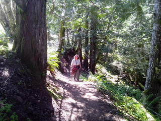 The hike turned out to be perfect: a well-maintained trail, mostly dry. The flora was gorgeous this time of year: everything lush and green, lots of clover and moss and flowers that I cannot name. I loved the views from high above down onto streams below. There are some mud pits and streams we had to hop over or ford, and the rocks in the stream crossings could be quite slippery - and it can feel a bit scary when you're very high up on the side of a steep hill, trying to cross a stream on slippery rocks. There are hills, and at a few points, the trail is quite steep. You will go up and down a lot, but if I can get my fat ass up and down it, anyone can. It was shade almost the entire way, which is what we prefer on hikes. The entire day, we met about 10 mountain bikes, all of them going uphill, and only about four groups of hikers - we were stunned at how few people we met and how alone we were most of the time on such a gorgeous Saturday.
Being the dumbass that I am, I forgot my hiking sticks. I really do need them, especially for steep hikes, up or down. Luckily, some kind soul left a self-made walking stick at a point near the start of the trail where it could easily be seen. It was hugely helpful for the hike, especially for those tricky creek crossings. I left it at the trail head after we came back - hope someone else got to use it.
You think you are going to hear ATVs and dirt bikes the entire time hiking - you aren't. We didn't hear them most of the time, despite there being oh so many on their own OHV trails all around.
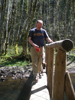 The footbridge over the river is very narrow and not for anyone absolutely terrified of heights. I am quite scared of heights, but can usually swallow my fear to do something I really want to - I took the ski lift one summer in Lillehammer, Norway, and though I was terrified the entire time and shivered all the way up, I was willing to do it to see the view up top, and that was oh-so-worth it. The footbridge here is so much skinnier and higher above the water than it looks in our photos. Stefan had to walk Lucy over because I was too scared - if she panics, I'll panic, and we'll both end up falling off the bridge and breaking our legs. So oh-so-calm Stefan led her over both times.
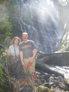
We got to University Falls at the perfect time - the seven people there were finishing up their visit and leaving. We ate lunch there by ourselves for several minutes, and when a group of people showed up, it was time for us to leave. The falls can get quite crowded, since there is a parking lot above the falls and most visitors drive there, but our timing was perfect and we avoided the crowds.
On our way back out on the trail, unfortunately, someone started shooting at a nearby quarry. The sound of gunshots so close by was terrifying. Lucy did well - she was curious, but never panicked. We met one group of hikers that had turned around and was going back to the trail head, scared of where the guns were and where the bullets were going. After about 30 minutes, the shooters let off a large explosion, and I had an immediate, split-second PTSD moment, thinking, "I've got to call security" and then realizing I wasn't in Afghanistan. I was much more annoyed than traumatized, but because of the shooting, I'd have to advise anyone who has served in a combat zone, in the military or as an aid worker, who has issues with the sounds of gunshots and explosions, to think twice before doing the Gravelle Brothers Trail.
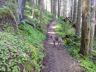 Lucy stayed on the trail almost the entire time, and well out front of Stefan on her leash - it was only when we left University Falls that she suddenly wanted off the trail to smell things under bushes, but that only lasted for about 20 minutes, tops. Lucinda's favorite parts of the hike were meeting other dogs! She was scared of all people we met on the trail UNLESS they had a dog - then they were just dandy. At the end of the hike, as we were about to get in the car to leave, two horses came by. We think this was Lucy's first time seeing horses. She was spellbound - but didn't bark. She's the first of my four dogs not to have a meltdown over horses. As they passed, I said, "See, Lucy, see those HUGE dogs?!" And Stefan said, "Yeah, Lucy, some day, you will grow up and be that big, and then we'll ride YOU!" And Lucy chose that exact moment to give Stefan a scared look, and we laughed and laughed...
Some people did have their dogs off leash on the trail, but their dogs were right next to them, and I think that's okay - but you should not have a dog far out ahead of you, on leash or not, as they could get hit by a bicyclist, and that would be a tragedy for everyone.
The Tillamook State Forest is a 364,000 acres (1,470 km2) publicly owned forest in the U.S. state of Oregon. Managed by the Oregon Department of Forestry, it is located 40 miles (64 km) west of Portland in the Northern Oregon Coast Range, and spans Washington, Tillamook, Yamhill, and Clatsop counties. We intend to see a LOT more of it in the coming years!
No comments:
Post a Comment